Spring Creek Watershed Action Plan (SCWAP) Update from David Roberts

David Roberts, Chair of the Nittany Valley Environmental Coalition Working Group for the Spring Creek Watershed Action Plan, attended the first meeting of a new technical work group established by the Spring Creek Watershed Commission on Thursday, August 23.

Links to David Roberts’ meeting notes, SCWC meeting notes, a participants list, and project funding data, are below.

Key excerpts from David’s report:

SCWAP Goals

The overall goal is for Restoration, Protection, and Sustainable Usage of the water in the 
Spring Creek Watershed through an “integrated, one-water plan.”

  • Phase 1 was completed in 2003.
  • The current project is Phase 2, focused on project identification and implementation. The timeframe for completion of Phase 2 is within months, not years.
  • Phase 3 will be tracking new data and evaluating success of Phase 2 plan implementation.

Brief Overview of Spring Creek Watershed

Watershed includes Spring Creek, five major tributaries, and numerous smaller tributaries. The watershed covers an area of 146 square miles (approximately 43,000 acres) and touches 14 local municipalities.

Watershed population has increased rapidly since 2000, from 106,006 people to 130,748 as of 2017. 
Population data does not appear to 
include PSU University Park population.

Some streams are designated as high quality cold water fisheries.

Twenty-five (25) miles of streams and tributaries are classified as degraded and impaired including Slab Cabin Run and the main stem of Spring Creek, suffering impairments such as sedimentation and siltation; low dissolved oxygen levels; thermal modifications from agriculture, golf course, and stormwater runoff; heavy metals; organics; point source discharges; nitrogen; and total dissolved solids.

The Phase 1 Plan (completed in 2003) identified issues and concerns about the health of the watershed. Many of those same issues still remain.

NVEC requested current data on the amount of impervious surfaces in the watershed. 
Available estimates are a few years old and place impervious surfaces at approximately 15%. Other watershed studies have shown that over 10% impervious surfaces are deadly to native trout populations. The Spring Creek trout population persists due to the karst geological formations that provide cold water spring habitats.

Next Steps

At the technical work group meeting August 23, Janie French, Executive Director of Headwaters Charitable Trust and facilitator of the SCWAP Phase II project, presented an overview of the steps needed, including:

  • Determining the current health status of the watershed
  • Bringing together existing data and ideas in a useable format.
  • Identifying and filling data gaps

The technical work groups will meet several more times in September and early October to collate available data, ahead of a public outreach/public education meeting October 18.

More details on some of the participating technical work group members:

The Spring Creek Watershed Commision Water Resource Monitoring Project (WRMP) maintains 27 water quality monitoring stations in Spring Creek and tributaries recording water flow and temperature, and monitoring other water quality parameters such as inorganic chemicals. Reports are available online for years 1999 to 2017 and the 2018 report will soon be posted

The Susquehanna River Basin Commission is an interstate regulatory agency responsible for regulation of water withdrawals, including consumptive use and high volume withdrawals from surface and groundwater sources, and plays a support role for water quality and water protection issues.

Whitehall Road Regional Park Development Update – “Stop and Re-do.”

The Whitehall Road Regional Park boondoggle has been going on since about 2002, and there are too many horrible twists and turns along the way to summarize.

Collection of source documents below; if you really want more detailed history, contact Katherine Watt and ask for it. But honestly, the more you understand, the more disgusted you’ll be, so feel free to ignore the sordid past.

PRESENT DAY…

The Centre Region Parks & Recreation Authority will try to take another step toward realizing their taxpayer rip-off vision, when CRPR Director Pam Salokangas appears at the Centre Region Council of Governments General Forum meeting on Monday, August 27 at 7 p.m. to give local legislators a project update.

Nittany Valley Environmental Coalition’s Randy Hudson has been focusing on public accountability and design problems with the WRRP project, drafting memos to local governing entities and appearing at public meetings to comment.

Readers interested in reinforcing Randy’s basic message of “STOP AND RE-DO” are encouraged to attend:

  • Monday, Aug. 27 COG General Forum meeting (7 p.m. at 2643 Gateway Drive), and
  • Thursday, Sept. 10 Ferguson Township Parks and Recreation Committee meeting (4 p.m. at Ferguson Municipal Building Conference Room 2, 3147 Research Drive).

IMPORTANT PROCEDURAL NOTE:

Salokangas has successfully blocked elected General Forum members from engaging in full discussion and votes on WRRP issues for the past two years, by restricting all but one of her presentations (May 22, 2017) to “information only” or “of record” formats.

This has also blocked public comment before and after her WRRP presentations, because the topic is not deemed “actionable” for the General Forum, and therefore General Forum is uninterested in public concerns.

If you attempt to make a public comment just before or just after Salokangas’ presentation on August 27, your voice will be shut down by General Forum Chair Danelle Del Corso.

If you wish to speak about WRRP on August 27, make sure you raise your hand and head to the podium at the very start of the meeting, right at 7 p.m., for the public comment period set aside for topics “not on the agenda,” even though WRRP will be on the agenda.

It makes no sense. Welcome to your local government.

Other meetings to consider attending to speak:

  • Thursday, Sept. 16 COG Parks Capital Committee, 12:15 p.m. at 2643 Gateway Drive.
  • Thursday, Sept. 20, Centre Region Parks and Recreation Authority, 12:15 p.m. at Bernel Road Park, 2501 Bernel Road.

BACKGROUND MATERIALS

Email message sent by Nittany Valley Environmental Coalition to Centre Region Council of Governments and Ferguson Township Board of Supervisors on Monday, August 20.

Dear Mr. Steff, Ms. Del Corso, Mr. Buckland, Mr. Miller, Ms. Dininni, Ms. Carlson and Mr. Ricciardi:

Attached please find a letter from Randy Hudson of the Nittany Environmental Coalition, reflecting our membership’s concerns with the proposed Whitehall Road Regional Park design and the processes used to prepare it.

8.20.18 NVEC Letter to CRCOG GF, FT BoS Re WRRP

Along with the letter, please find a graphic representation of data about community regional park preferences, collected in 2008 by the Centre Region Parks and Recreation Authority and collated by NVEC in July 2018.

2008 Community Park Survey Data

We also include a graphic representation of the relative WRRP budget allocations for rectangular field park development and for green/open space park development, based on cost estimates that were available to NVEC in July 2018.

July 2018 WRRP Comparative Budget Allocation Estimates

We are in the process of updating this chart in light of updated project cost data that became publicly available on August 16, 2018 during the CRPRA Board meeting.

It is our current understanding that:

Thank you for your attention to these important matters of public concern.

Community Survey 2008 – Regional Park Amenities

Community Survey 2008 – Regional Park Amenities

This is a graphic based on data collected by Centre Region Parks & Recreation in 2008, about what community members surveyed at that time wanted to see in the proposed regional parks.

From about 2002 to the present, soccer, lacrosse, softball and tennis proponents have been extremely engaged with CRPR staff and the CRPRA board to promote their desire for active sports facilities as a higher regional priority than green space/open space facilities.

This data set shows overwhelming community support for passive uses, similar to uses proposed by the Ferguson Township Board of Supervisors in a March 2018 memo to CRPRA and endorsed by Nittany Valley Environmental Coalition in a July 2018 memo to CRPRA, urging that acreage in the proposed Whitehall Road Regional Park be placed into conservation, pollinator plantings, meadows, reforestation, walking trails and other water conservation uses.

These graphics and notes can be used by anyone who wants to promote water-protective public land use at upcoming public meetings, especially the COG General Forum meeting on July 30, 7 p.m. at 2643 Gateway Drive.

Another point, not specifically highlighted in the notes on the graphic – is that regional park amenities data (both inventories of existing facilities and needs assessments) is extremely outdated.

It would make sense to urge COG General Forum representatives to postpone regional decisions about public land use at COG- and FT-owned Whitehall Road Regional Park until after the Regional Comprehensive Parks, Recreation and Open Space Study is completed in 2019.

From the RFP: “The purpose of this study is to evaluate and make forward thinking recommendations on the parks and recreation opportunities in the six Centre Region municipalities. A particular focus will be the facilities, programming, funding, and governance structure of the Agency.”

That two-year study process was funded by COG General Forum back in 2017 partly as a result of the TB/WRRP fight, which highlighted the lack of a comprehensive regional parks needs assessment and plan. The study will include an updated inventory of all park facilities (regional, municipal, school district, etc.) and an updated, data-supported needs assessment.

The bid process for a consultant is now open, bids are due by August 7, and the study should be completed by next summer.

Spring Creek Watershed Action Plan Update

In the short-, medium- and long-term, it appears that the best way for concerned citizens to protect our regional water supply and the ecosystems that depend on it for life, including the human population, is to adopt a watershed action plan that has strong enforcement components.

On July 10, the Spring Creek Watershed Commission (SCWC) kicked off the process of updating the Spring Creek Watershed Action Plan (SCWAP), which was abandoned in 2003 after Phase 1, due to funding and civic momentum shortfalls.

SCWC has created an excellent new website, including a page for coordination of the update process.

The update process is being led by Janie French, executive director of Headwaters Charitable Trust.

There were about 50-60 people at the kickoff meeting, held at Calvary Baptist Harvest Fields in Boalsburg. After an introductory presentation, the group was split into four smaller groups to begin talking about what we want our watershed community to look like in the future, and what actions could contribute to bringing about those results. Then there was a report-back.

One of the key issues identified by all four small groups was the need for watershed protection measures to be locally enforceable, to “have teeth.”

Ms. French then announced that the four groups would be meeting bimonthly during July, August and early September to continue the process of reviewing the Phase 1 report and setting foundations for the drafting of Phase 2. Public, large-group meetings will then resume, probably in September and October.

Broad community engagement is important, so if you didn’t go to the July 10 kickoff meeting but would like to get involved in the small group meetings, please contact SCWC Communications Coordinator Caitlin Teti at springcreekwatershedcommission@gmail.com and ask to be added to one of the small groups meeting for the next few weeks.

SCBWA Board denies Toll Brothers easement request

On Thursday, July 19, the State College Borough Water Authority Board denied Toll Brothers request for an easement which, if granted, would have allowed the developer to run a high-pressure sewage pipeline across SCBWA land purchased in 2008 for water conservation, with deed restrictions memorializing that purpose and running with the land.

6.20.08 PSU to SCBWA Deed

The vote was 4-1, with Bernie Hoffnar, Bill Burgos, Rachel Brennan and Jason Grottini voting to deny the easement, Gary Petersen voting to grant the easement, Jeff Kern not voting and not abstaining, and Emory Enscore absent.

The video from the meeting is available via CNET on YouTube.

It was a remarkable result, and the discussion was riveting, focused on the water board’s ethical obligations to protect public water.

The discussion also included the revelation that Toll Brothers attorneys threatened to file suit in federal court if the water board used its discretion as landowner to deny the easement.

Background reporting:

SCBWA Meeting July 19

The State College Borough Water Authority will be reconsidering Toll Brothers’ request for an easement permitting construction of a sewage conveyance pipeline across deed-restricted conservation land owned by SCBWA, at the water authority’s meeting Thursday July 19 at 4 p.m. at 1201 West Branch Road.

For background, please read May 1, May 7 and May 21, 2018 Bailiwick News reporting.

See also: Attorney Jordan Yeager letter to SCBWA re: proposed easement, legal implications of covenant on SCBWA land – 5.3.18 Yeager Letter to SCBWA

NVEC Statement Re Whitehall Road Regional Park Design

Nittany Valley Environmental Coalition July 9, 2018 Memorandum to Centre Region Parks and Recreation Authority Board regarding Whitehall Road Regional Park Design Considerations

7.9.18 NVEC Letter to CPRPA Re WRRP

From G. Randolph Hudson, Architect, LEED AP, and Chair, NVEC Working Group for Whitehall Road Regional Parkn Design, via email to Ms. Kathleen Matason, Chair, Centre Region Parks & Recreation Authority (CRPRA) Board and Ms. Pamela Salokangas, Director, Centre Region Parks & Recreation (CRPR).

Dear Ms. Matason and Ms. Salokangas:

The proposed regional park design at Whitehall Road has a long way to go before it meets the agreed-upon needs of our local population. Ask people in our region, or anywhere, what a “park” is, and they imagine something very different from this plan. CRPR’s own surveys, from at least 2008 on, show ten times the desire for open space (trails, trees and flowers, picnic areas, sledding areas) as there is for structured sports. (11.7.08 Regional Park Survey11.7.08 Regional Park Comments)

This is consistent with surveys from around the nation.

Yet the proposed Phase One of Whitehall Road Regional Park devotes a great deal of area, and by far the greatest tax dollars, for organized sports and its parking, rather than for what the community says it needs. A great local park, on the other hand, might more closely resemble Penn State Arboretum or Pittsburgh’s Schenley Park.

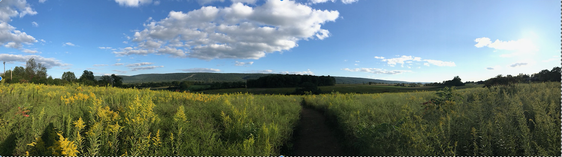
The Heart of Nittany Valley

The site of the proposed Whitehall Road Regional Park is one of the most stunning natural areas in Central Pennsylvania. It offers magnificent vistas of Mount Nittany, Tussey Ridge and thousands of acres of open fields and meadows. It defines the essence of the term “viewshed.” I strongly encourage any stakeholder who has not walked this site to do so, while all its potential can still be imagined.

Natural beauty is precious. It is why people love to live here. Particularly since the Penn State/Toll Brothers chapter, policymakers must consider not only built fields and facilities, but also preservation of resources, undeveloped views and open space, and Pennsylvania’s wildlife in determining the final mix of amenities for our region. Accordingly, Nittany Valley Environmental Coalition encourages the Centre Region Parks and Recreation Authority Board to take a broad view of what constitutes “Parklands.”

The current plan places far too much emphasis on team sports. This is not the place to emphasize those.

NVEC SUPPORT FOR FERGUSON TOWNSHIP LETTER

The Nittany Valley Environmental Coalition strongly supports the letter of March 21, 2018 to the CRPRA Board, written by Ferguson Township Manager David Pribulka on behalf of the Ferguson Township Board of Supervisors.

The Ferguson Township letter asks that the next planning and design phases adhere to the already agreed-upon principles stated in the Whitehall Road Regional Parklands Master Site Plan (“Whitehall Parklands”) document created in August 2010 for the Centre Region Council of Governments. The document was the result of a comprehensive stakeholder-supported master plan process.

Ferguson’s letter emphasizes the following points, presented here with expanded NVEC comments:

Encourage permeable paving for parking and roads. Encourage paved rather than gravel surfaces.

Additionally:

  1. Design number of parking spaces not to perceived desires, but to code minimums.
  2. Shade paved areas—both roads and parking–with trees to reduce heat islands. We understand that shading was originally planned, but later removed. This is contrary to all good planning practice in the last 20 years.
  3. Refer to LEED standards for site and other facility planning. Although certification is not required, these offer realistic and proven design guidelines.

Do not “improve” undeveloped portions of park. Since there is no timetable for future phases: Request no grading; preserve natural habitat. Consider succession planting and reforestation.

  1. Do not grade either Phase One areas labeled “Future,” or Phase Two areas. Do not disturb this local birding hotspot.
  2. As this is recent farmland, with heavy spraying, wildlife and beneficial insects have been impaired. Management plans must include cessation of herbicides and pesticides.
  3. Consider the Wildlife Management Institute’s Young Forest Guide principles, allowing areas for brush and young trees to grow up. These areas are “powerhouse” habitats for grouse, whip-poor-wills, reptiles, including turtles, and migrating birds.

Update the Parklands Master Plan for subsequent phases as Phase One is developed.

Additionally: Make this an inclusive and transparent process, with broad community input.

Green infrastructure and low impact parkland for this and subsequent phases. Consistent with 2010 planning document, through the Sustainable Sites Initiative.

Mitigate light and noise pollution. Consider screening and natural buffering with height to prevent spillover light to adjacent properties.

Additionally:

  1. NVEC respectfully requests that there be no site lighting. Besides the initial and yearly expense, night lighting affects not only adjacent properties, but will be visible for miles. It disrupts views of the night sky, bird migration and human health.
  2. Consider stargazing as a popular, free outdoor activity that is difficult in town. Ideally, consider a sky observatory to complement PSU Davies Lab.
  3. If there is lighting, it should conform to International Dark Sky Association (IDSA) standards, with zero off-site light spillage. Security lighting, if any, should be by motion-detector only.
  4. Noise: NVEC respectfully requests no amplification/announcement systems. Pine Grove Mills already hears both Kocher Stables and Beaver Stadium loudspeakers. Loudspeakers here would be highly disturbing to adjacent and distant residential areas.
  5. For noise control, establish hours of operation, and standards for activities and decibel levels in accordance with local ordinances, police, and community wishes.
  1. RECAP OF WHITEHALL PARKLANDS PRINCIPLES

NVEC respectfully offers reminders of these principles from Whitehall Parklands:

Plan first for the views and natural areas, then for the ballfields. Chapter One of Whitehall Parklands: The site is “exceptional in its scenic position with outstanding valley views” and has “spectacular…scenic values.” Any coach will tell athletes: “Keep your eye on the ball.” Views like these are vital for visitors, far less so for athletes.

Less is More. While recognizing a need for active playing fields, give top priority to lifetime activities. Or to simple relaxation. Consider also that sometimes the best thing is “nothing.” One of America’s most iconic park features, Central Park’s Sheep Meadow, has no structures or structured activity. Reserve Whitehall Parkland’s best view areas for non-sports use. From Whitehall Parklands: “…diversity of complementary activities is important to creation of a great park.”

Xeriscaping. 1. Plant native grass, shrub and tree species that, once established, require no watering, herbicides or pesticides. This provides tremendous yearly savings in maintenance. As a bonus, these will allow pollinator, beneficial insect, and bird populations to rebound. 2. Carry out sports turf design, and a management program, that reflects this.

Invasive-species control. Invasive plants are a growing problem in Ferguson Township and statewide. Invasives crowd out native plants, starving birds and wildlife; this cost must be included in operations budgeting.

  1. ADDITIONAL THOUGHTS FROM NVEC

Eight years have elapsed since the original Whitehall Parklands plan. Much has changed since then, and current planning must reflect this.

Maintain safe water supplies.

Whitehall Parklands is above and within the recharge area of the Harter and Thomas well fields providing drinking water to 75,000 State College area residents, above fragile karst limestone geology prone to sinkholes and fractures.

  1. Construction and operation must not risk the safety of nearby State College Borough Water Authority wells and Slab Cabin Run. Accordingly, re-grade as little as possible of either Phase One or Phase Two. Do not re-grade now for future facilities.
  2. Plan now for who is responsible if wells or stream are damaged.
  3. Consider having the State College Borough Water Authority board certify the project as non-risk, absolving the Parks Authority and COG of liability for damages.

Provide the full range of amenities at every phase, including Phase One

At every phase, the Parklands should contain the full blend of active, passive and natural areas, in similar proportions to those at completion of all phases. Phase One must, at a minimum, include the community gardens designated as “future” in the site plan.

Providing this full range will be more economical than a plan that prioritizes sports fields. It will help meet the three General Forum goals: small enough to cost $4.8 million or less; within the (Whitehall Parklands) design area and with a broad enough range of features to be accepted unanimously by municipal legislators as a “regional” park.

Are sports fields in fact necessary?

A casual drive around our region shows dozens of empty municipal and school fields everywhere, at all hours. A simple scheduling fix could eliminate or greatly reduce the need for expensive new fields.

  1. Confirm current regional capacity and needs.
  2. If the desire is for club tournaments, then recognize that concentrating the fields in one location may be ideal, but it is not a need.

Re-Consider Artificial Turf.

The manufacture of artificial turf is highly energy-intensive and has severe impacts on water supplies. Surface runoff of rubber and plastic micro-particles will discharge directly into our water supply.

  1. Consider installing natural turf only, incorporating a “resting” field to allow recovery between seasons/years of use.
  2. If artificial turf is used, apply current best practices for sourcing the materials and managing runoff. This discipline is evolving rapidly.

Advanced Engineering for All Aspects.

Sophisticated engineering can be applied to all features of the Parklands, not only sports fields.

  1. Consider hydro-engineering to provide water features, including water for birds and wildlife, and as viewer focal points.
  2. Consider engineered gravel for roadways.
  3. Incorporate outdoor learning and STEM opportunities for local students.

Consider Topography.

The proposed Parklands occupy a “hogback”: a high tableland with stunning 360-degree views. No plans or studies, even Whitehall Parklands, have included slope analysis.

  1. The best views must be reserved for the amenities that benefit from views.
  2. The rise tilts down toward Whitehall Road, therefore fields may be highly visible. Consider this in final layout of fields vs. natural areas.
  3. Minimize re-grading, cut and fill, and retaining walls. Consider a peer review of current site plan document. There are large potential cost savings even in Phase One.

Fill in the Skipped Steps.

 Whitehall Road Regional Park was planned in 2010 by an interdisciplinary team of land planners and landscape architects, with input from a wide range of stakeholders. Fast forward to 2018. Construction documents are being drawn for a piece of that plan by a very capable firm, but one whose core business is infrastructure engineering. In my experience, when that much time has elapsed, there is a re-visit of basic programming assumptions and design response.

  1. Considering what our community now needs and is requesting, pause and carry out program confirmation.
  2. Before proceeding with construction drawings, hire a landscape architect firm to create schematic and preliminary landscape architecture plans that take into account views, slopes, sun; trees and other vegetation, and surface and groundwater.
  3. Carry out programming and design in a public process.

Maintain cost effectiveness.

Maintain focus on both costs of construction and of subsequent operations. Reduce cost of both, by focusing on the stated needs of the Centre Region population.

The Nittany Valley Environmental Coalition thanks you, your staff and all who have worked on this to date, and looks forward to helping to realize the fullest potential of this stunning property as true parklands for the entire community.

Sincerely,

/s/ Randy Hudson

cc via email

  • Denise Meyer, Ferguson Township Representative to CRPRA Board
  • Ferguson Township Park Committee Members: Shawna Doerksen, Niki Tourscher, Norris Muth, Connie Puckett,
    Laura Moser, Kathie Vondracek and Andrew McKinnon
  • COG Parks Capital Committee Members: Janet Engeman (State College); Laura Dininni (Ferguson Township); Bruce Lord (Harris Township); Eric Bernier (College Township); Jessica Buckland (Patton Township); Charima Young (Penn State University)
  • Dave Pribulka, Ferguson Township Manager
  • Jim Steff, Director, Centre Region COG
  • Jim May, Director, Centre Region Planning Agency

NVEC Position Statement Re Spring Creek Watershed Action Plan

6.25.18 NVEC SCWAP Press Release (PDF)

PRESS CONTACT: David Roberts, Working Group Chair, NVEC Working Group for Spring Creek Watershed Action Plan (SCWAP), 814-769-0550, nvec2018@gmail.com

Position Statement: Spring Creek Watershed Action Plan

Nittany Valley Environmental Coalition strongly supports the Spring Creek Watershed Commission’s efforts to update and complete a Spring Creek Watershed Action Plan. An early phase of this integrated watershed management plan was last updated in 2003. [2003 Spring Creek Watershed Plan – Phase 1 Report (PDF); 2.6.17 Spring Creek Watershed Plan Executive Summary (PDF)]

We further strongly encourage all interested watershed stakeholders to participate in the Commission’s Tuesday, July 10, 2018 meeting to kick off the process of updating and completing the Spring Creek Watershed Action Plan, to be held at 6:30 p.m. at the Calvary Baptist Harvest Fields building at 150 Harvest Fields Drive, Boalsburg. (Entrance is via Discovery Drive off Business Route-322).

Spring Creek Watershed Commission asks participants to register by Tuesday, July 3.

Summary:

The Spring Creek Watershed needs an integrated watershed management plan[1], defined by the international Global Water Partnership as: “a process which promotes the coordinated development and management of water, land and related resources, in order to maximize the resultant economic and social welfare in an equitable manner without compromising the sustainability of vital ecosystems.”

Regional and municipal governments and authorities were established to protect public health and safety, including protection and conservation of public water resources.

But recent public disagreements, incursions of development into sensitive, protected areas, aging infrastructure with excessive water loss, and a lack of cooperation between townships demonstrate the urgent need for a science-based regional watershed management plan.

The current actions by the Spring Creek Watershed Commission present a great opportunity for our communities and our representatives to work together to craft an enforceable watershed management plan.

Open and inclusive public involvement is key to project success.

Our understanding is that drafting, adoption and enforcement of a Spring Creek Watershed Action Plan is a multi-phase, multiyear process in which public and stakeholder information and discussion sessions are crucial, bringing people together to discuss, analyze, and resolve water use issues and challenges. Stakeholders include decision-makers and key water advocacy organizations, and the public includes everyone living in the watershed.

Phase 1 – Includes public meetings to clarify our community understanding of the entire system – public water supplies and natural aquatic systems – as one integrated system; to study and evaluate water system risks from land development and from climate-driven impacts; to develop general action plans to protect and conserve existing water resources from further degradation; and to develop action plans – including a water budget – designed to measurably improve and restore streams, wetlands, aquatic ecosystems and water-dependent terrestrial populations, including but not limited to humans.

Phase 2 – Includes development of specific “green” and “blue-green” infrastructure projects[2]; funding mechanisms for those infrastructure projects; and adoption of the final Spring Creek Watershed Action Plan by the participating municipalities and municipal authorities such as the State College Borough Water Authority and the University Area Joint (Sewer) Authority.

Phase 3 – Includes updating municipal codes with enforceable legislation and policies – such as zoning code updates and stormwater management ordinance updates – to implement the Spring Creek Watershed Action Plan at the municipal and municipal authority level.

Some aspects of a watershed plan will be enforceable as soon as the regional plan is adopted by the participating municipalities and municipal authorities, and before adoption of specific implementing local regulations, through state oversight of local development proposals by the Pennsylvania Department of Environmental Protection (PA-DEP) under legislative statutes.

For example, a complete, adopted regional Spring Creek Watershed Action Plan would be considered “Local Planning” under Act 537, related to sewage management, which requires all proposed sewer projects to serve existing and proposed land development projects to be assessed for consistency with local planning.  Similarly, the interstate Susquehanna River Basin Commission would likely refer to a complete, adopted Spring Creek Watershed Action Plan when evaluating consumptive use permit applications such as the Nestle bottling facility proposed earlier this year.

Nittany Valley Environmental Coalition therefore asks for citizen support and engagement in the drafting and adoption a regional Spring Creek Watershed Action Plan; in the drafting and adoption of appropriate local municipal legislative and regulatory plan-implementing actions; and in oversight and enforcement of the adopted plan and implementing legislation by local, county, state and inter-state governmental agencies in the years to come.

Our Water is Vulnerable

Centre County has limited, vulnerable water supplies.

The need to protect and conserve our public water resources is growing more urgent from the real threats we face including:

  • Risk of depletion of local water supplies and lowering of water tables
  • Increased potential for groundwater contamination
  • Projections of drought, flooding and other severe weather effects of climate change. For example, droughts reduce the available water stored in the aquifers, heat surface waters and reduce stream flow.  Flooding scours streambeds, damages infrastructure, destroys aquatic habitat, and transports contaminants into water supplies.
  • Development upon sensitive aquifer recharge areas
  • Fragile health of Spring Creek water basin
  • Loss of forested water recharge areas
  • Degradation of riparian stream systems
  • Reduction of flow to named and diffuse fresh water springs
  • Reduction of gaining stream inflow
  • Increased groundwater withdrawals
  • Reduction of cold water habitat for native trout
  • Increased surface and stormwater runoff from impervious surfaces
  • Growing wastewater treatment needs
  • Aging infrastructure

Centre County will continue to face demands to tap our water resources and proposals to expand development into sensitive and fragile watershed areas.

State and local water-protection laws and systems are weak

The Pennsylvania Constitution states that:

“The people have a right to clean air, pure water, and to the preservation of the natural, scenic, historic and esthetic values of the environment. Pennsylvania’s public natural resources are the common property of all the people, including generations yet to come. As trustee of these resources, the Commonwealth shall conserve and maintain them for the benefit of all the people.” (Pa. Constitution, Article I, Section 27).

However, our water laws are mostly based on old common law precedents and common law court decisions with few statutory provisions from our state legislators.

These common law precedents did not envision the impacts, challenges and opportunities presented in the 21st Century.

In addition, Pennsylvania generally follows the “American Rule” on water use. However, “The American rule is not designed to deal with conflict between competing users or with drought conditions. Its provisions usually mean that those with the deepest wells and most powerful pumps get the most water.” (State Water Plan, 1976; Weston, 1990).

The 1996 League of Women’s Voters PA water law summary identified a number of problems with Pennsylvania’s laws including:

  • no mechanisms to address potential problems for our future water needs
  • no guarantee that our water rights will continue undiminished
  • no provision for resolution (other than litigation) of competing water uses
  • no provision for increased per capita demand for water
  • no provision for conservation of water
  • no provision for dealing with increase of conflicts during droughts
  • a fragmented system of water management.

Our local existing water management plans are also weak and unenforceable. Centre County has around 48 separate water authorities with independent water management systems and decision-making policies.

Municipal code provisions are fragmented across township boundaries and are failing to function as representative of the general public good with regard to our water resources, which are physically shared across political boundaries.

How a Spring Creek Watershed Action Plan can help.

An integrated watershed management plan will provide an equitable, science-based framework for towns and municipal authorities within the Spring Creek Watershed to manage these threats and to implement the decision-making processes necessary for the conservation, protection, and beneficial use of our public water into the next century.

A successful integrated water plan is a pathway forward and the means for our government representatives to make fair, common sense decisions while considering the water needs of all local stakeholders – including human and other terrestrial animal populations and aquatic ecosystems.

Ideally, the plan will protect our water while helping to avoid potential disagreements between the public, businesses, and our local decision-makers on water management issues.

The benefits of a strong, clear, enforceable regional Spring Creek Watershed Action Plan – and local implementing legislation – include:

  • Availability of fresh, potable water for Centre County’s many and diverse needs
  • A clear approval mechanism for water use
  • Integration of water management across township and municipal boundaries
  • Protection and conservation of watershed basins
  • Proper management of public water resources
  • Equity for shared stakeholders
  • Funding mechanism for infrastructure maintenance and expansion,
  • Restoration and improvement of currently degraded natural aquatic habitats
  • Preservation of recharge areas
  • Increased tourism revenues
  • Enhancement of community recreational opportunities
  • Science based monitoring systems to measure benchmarks and progress
  • Plans to counter potential drought and flood conditions
  • Clearly defined and established goals
  • A mechanism to assure abundant water resources for the next 50 years.

For more information or to get involved with NVEC’s work supporting a Spring Creek Watershed Action Plan, please contact David Roberts, Working Group Chair, NVEC Working Group for Spring Creek Watershed Integrated Management Plan, at the contact information listed above.

[1] For a general overview of integrated water management, visit:

What Is Integrated Water Management?

[2] From Wikipedia: Green Infrastructure or blue-green infrastructure refers to projects that help “solve urban and climatic challenges by building with nature. The main components…include stormwater management, climate adaptation, less heat stress, more biodiversity, food production, better air quality, sustainable energy production, clean water and healthy soils, as well as the more anthropocentric functions such as increased quality of life through recreation and providing shade and shelter in and around towns and cities.”

For a lengthy list of additional informational resources, please download the full press release PDF document: 6.25.18 NVEC SCWAP Press Release

IMPORTANT WATERSHED MEETING JULY 10 in BOALSBURG

The Spring Creek Watershed Commission invites watershed stakeholders to the first of several stakeholder’s meetings to begin the update for the Spring Creek Watershed Plan Management Plan, “Our Challenges and Direction for the Future.”

The meeting will be held on Tuesday, July 10, from 6:30 to 9 PM at Calvary Harvest Fields in Boalsburg.

The goal of this update is to examine The Spring Creek Watershed Plan Phase I Final Report — 2003 Spring Creek Watershed Plan – Phase 1 Report (PDF); 2.6.17 Spring Creek Watershed Plan Executive Summary (PDF) — to delete obsolete information, refresh and upgrade data, add new relevant information, incorporate government roles in addressing watershed issues that create legislative mandates and municipal undertaking relevant to preserving and improving the quality of the Spring Creek Watershed. (Emphasis added)

Spring Creek Watershed Commission values community input on this integrated watershed management plan and hopes many community members will attend. 

Details on how to register will be forthcoming in the next couple of weeks.

In the meantime, please mark this meeting on your calendars.

Spring Creek Watershed Commission is  looking forward to valuable community input and asks people to please reach out via email to springcreekwatershedcommission@gmail.com  with any questions or concerns.

Please come to the meeting with a general understanding of the Phase I report.

EDITOR’S NOTE: 

The Executive Summary is an excellent history of the project, compiled by Bill Sharp in February 2017, explaining that the watershed management planning process stalled in 2003 due to lack of funding and community engagement. With renewed community engagement thanks to the Toll Brothers/PSU attack on the SCBWA Harter-Thomas wellfield recharge areas along Whitehall Road, and the Nestle approach to the Logan Branch sub-basin for water extraction, bottling and export, now is a great time to push the plan forward to create stronger community tools for protecting water.


Executive Summary:

The Spring Creek Watershed Plan Phase 1 Final Report: Our Challenges and A Direction for the Future

Compiled by Bill Sharp, Chair, Spring Creek Watershed Association, February 6, 2017 and reviewed by core members of the Association.

The Spring Creek Watershed Plan was a project of the Spring Creek Watershed Commission. It was funded by the Pennsylvania Department of Environmental Protection, facilitated by ClearWater Conservancy and supported by the Centre County Commission. It was compiled by two full-time ClearWater watershed staff and a Project Management Team. It was completed in 2003.

The list of major stakeholders involved included: ClearWater Conservancy, the Centre County Planning Office, the Centre Regional Planning Agency, University Area Joint Authority, the State College Borough Water Authority, the fourteen individual municipalities, the Spring Creek Chapter of Trout Unlimited, the Centre County Conservation District, The Pennsylvania State University, and others.

The stated objective of this phase of the Watershed Plan was “to distill numerous existing plans, research, and data into a clear and concise statement of the challenges facing the watershed and recommend ways that its citizens can meet these challenge in the future.”

The Project Team chose a focused approach resulting in a Challenge – Solution Matrix and supporting narrative. The Matrix sought to identify water resource challenges, potential solutions and in separate columns:

  • Solutions already studied, with referenced publications listed in appendices.
  • Solution needs to be further developed.
  • Opportunity to solve past problems.
  • Opportunity to solve future problems.

The four major components of the Matrix include:

  • Surface water with two main sections: Natural drainages and engineered drainages. Engineered drainage is tied directly to increasing developing and rising population.
  • Groundwater also has two components: Recharge and discharge related to a karst environment.
  • Water supply: Understanding the implications maintaining clean and plentiful drinking water and the challenges of wastewater treatment. Beneficial Reuse was highlighted as a concept that links treatment and consumption by recharging the aquifer.
  • Land Use decisions effect the potential quality of our water resources. There are also existing issues from past decisions that need to be addressed.

The Phase I report includes a narrative section for each of these four major components. Each section presented a number of challenges and potential solutions.

Water Resource Monitoring Project (WRMP):

Since 1998 the Spring Creek Watershed Community has been monitoring the Spring Creek watershed according to a protocol designed by a committee of local water resource experts. This effort continues to the present day. The WRMP has been a mainstay for the greater Watershed Community[1].

A Look to the Future:

Authorization of an effective implementing agency and ensuring sustainable funding will be instrumental in addressing the watershed’s challenges and ensuring the protection of all the interrelated components of our water resource system.

There are four appendices:

  1. Spring Creek Watershed Plans and Studies (17 listed to date of report).
  2. Watershed Plans and Integrated Water Resource Plans from other Watershed (22 items). A location map is provided for plans located in Pennsylvania.
  3. Watershed Related Studies and Resources (16 items)
  4. USGS Conceptual Model Report (Page blank: To be attached as a separate document).

In summary, the Project Team reported that the Phase I study was an important learning experience that “led to a change in overall watershed planning philosophy and the methods that the community will employ to carry out the next steps of the Spring Creek Watershed Planning and Implementation process.”

This was the Matrix.

A vision for continuing the planning and implantation process was outlined (for 2004). The Project team recommended:

  1. Project Selection: The Spring Creek Watershed Commission to prioritize and select the projects to advance to completion as Phase 2 of the Watershed Plan[2].
  2. Implementation: May require additional research, planning, communication, development of tools or processes, identification of funding source and project partner, and most critically, the project’s implementation in the watershed.
  3. Communication: Proposed that the Spring Creek Watershed Community (now Spring Creek Watershed Association) be made “the vehicle to facilitate communication of watershed issues and coordinate watershed-based projects.” It noted that there was currently staffing located at ClearWater Conservancy. It also noted that members of the Spring Creek Watershed Community were already exploring more efficient and effective ways to reach out to watershed stakeholders, evolving from the current Springs & Sinks publication and the website.

Two additional phases were planned:

  • Phase II: Watershed Plan Development (January 2004 – June 2005
  • Phase III: Watershed Plan Implementation (Beyond 2005)

Closing Notes:

DEP discontinued funding for the project. Administrative support for the Watershed Community declined after 2003. The last issue of Spring & Sinks was published November 2003 and discontinued due to lack of funding. The Water Resources Monitoring Program has continued to maintain files of documentation related to the watershed but there has been relatively less reporting of this activity.

The 2003 Watershed Plan document represented the culmination of nearly eight years of work by committed stakeholders in the Spring Creek Watershed Community under the leadership of the Spring Creek Watershed Commission.

Since then there has been a remarkable amount accomplished by major stakeholders which the Spring Creek Twentieth Anniversary Celebration Project (2016) documented and made public.

The Phase I Plan is a sound foundation document. However, thirteen years have lapsed since the completion of this project. Economic development and population in the watershed has actually increased beyond forecast and is expected to continue. Financial and administrative support have been lacking to continue development of the Plan and provide systematic management of the watershed.

With the hiring of Spring Creek Watershed Conservation Coordinator (Lexi Orr) by the Watershed Commission, a degree of administrative capacity has been restored and interest is building to move forward on the Watershed Plan.

[1] “Watershed Community” refers to not only the Watershed Commission and Association and ClearWater Conservancy but also to all entities that have an active interest in managing Spring Creek water resources.

[2] A list of priorities was developed by the Watershed Commission at a public meeting in March 2004.